Hi Everyone,
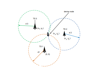
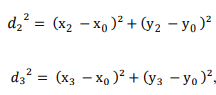
I have a mathematical calculation I needed solved, to do with the intersection of spheres.
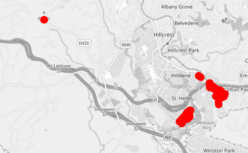
I have a node transmitting a message and it is received by 3 or more gateways (base stations). The location of the node is unknown and I want to calculate it.
The gateway location and the timestamp the message arrives is known.
The location is in the msg.payload.uplink_message.rx_metadata[i].location.latitude and msg. payload.uplink_message.rx_metadata[i].location.longitude
Time stamp is msg. payload.uplink_message.rx_metadata[i].time
Here I am showing an example of 3 gateways, but it could be a lot more, 4 gateways will give 3D accuracy.
The flow below is a inject node with the JSON in it.
[{"id":"333f342c.ef334c","type":"inject","z":"1f9de5c0.4c944a","name":"","props":[{"p":"payload"}],"repeat":"","crontab":"","once":false,"onceDelay":0.1,"topic":"","payload":"{\"end_device_ids\":{\"device_id\":\"24e124136a512983\",\"application_ids\":{\"application_id\":\"temperature-collection\"},\"dev_eui\":\"24E124136A512983\",\"join_eui\":\"70B3D57ED004305B\",\"dev_addr\":\"260BF170\"},\"correlation_ids\":[\"as:up:01FDP93T732QMWB77C2GWGB5M3\",\"gs:conn:01FCN5FJXHANYS2X1NTMQ9NKZY\",\"gs:up:host:01FCN5FJXWKEYM0CP1DCD3BFBA\",\"gs:uplink:01FDP93T056T1KWPXRAR2C5N7D\",\"ns:uplink:01FDP93T07FYVH0SEK6FD6G6MM\",\"rpc:/ttn.lorawan.v3.GsNs/HandleUplink:01FDP93T07PK65YNJWD0CRAPBF\",\"rpc:/ttn.lorawan.v3.NsAs/HandleUplink:01FDP93T72WEB48CMXWTJCBN0A\"],\"received_at\":\"2021-08-22T06:35:06.852634186Z\",\"uplink_message\":{\"session_key_id\":\"AXtn1vl04Sbzy4kNIDg/Cg==\",\"f_port\":85,\"f_cnt\":663,\"frm_payload\":\"A2eLAARokQ==\",\"decoded_payload\":{\"humidity\":72.5,\"temperature\":13.9},\"rx_metadata\":[{\"gateway_ids\":{\"gateway_id\":\"tech5-alverstone-02-dbn\",\"eui\":\"313330374E005900\"},\"time\":\"2021-08-22T06:35:06.519602Z\",\"timestamp\":506974466,\"rssi\":-104,\"channel_rssi\":-104,\"snr\":6,\"location\":{\"latitude\":-29.770195,\"longitude\":30.716669,\"altitude\":950,\"source\":\"SOURCE_REGISTRY\"},\"uplink_token\":\"CiUKIwoXdGVjaDUtYWx2ZXJzdG9uZS0wMi1kYm4SCDEzMDdOAFkAEIKi3/EBGgwImuCHiQYQpt2srAIg0N+h0OCF/QE=\",\"channel_index\":6},{\"gateway_ids\":{\"gateway_id\":\"tech5-gillits-01-dbn\",\"eui\":\"3133303746002800\"},\"time\":\"2021-08-22T06:35:06.523276Z\",\"timestamp\":388469847,\"rssi\":-115,\"channel_rssi\":-115,\"snr\":-9.25,\"location\":{\"latitude\":-29.796528,\"longitude\":30.790431,\"altitude\":647,\"source\":\"SOURCE_REGISTRY\"},\"uplink_token\":\"CiIKIAoUdGVjaDUtZ2lsbGl0cy0wMS1kYm4SCDEzMDdGACgAENeonrkBGgwImuCHiQYQsYP9rAIg2OftlKffYQ==\",\"channel_index\":6},{\"gateway_ids\":{\"gateway_id\":\"on-the-hill-01\",\"eui\":\"00800000A000104F\"},\"time\":\"2021-08-22T06:35:06.521836Z\",\"timestamp\":2525021188,\"rssi\":-74,\"channel_rssi\":-74,\"snr\":10.5,\"location\":{\"latitude\":-29.806432,\"longitude\":30.771859,\"altitude\":615,\"source\":\"SOURCE_REGISTRY\"},\"uplink_token\":\"ChwKGgoOb24tdGhlLWhpbGwtMDESCACAAACgABBPEISIg7QJGgwImuCHiQYQxtqLuAIgoN/2t76fDg==\",\"channel_index\":6}],\"settings\":{\"data_rate\":{\"lora\":{\"bandwidth\":125000,\"spreading_factor\":7}},\"data_rate_index\":5,\"coding_rate\":\"4/5\",\"frequency\":\"867700000\",\"timestamp\":506974466,\"time\":\"2021-08-22T06:35:06.519602Z\"},\"received_at\":\"2021-08-22T06:35:06.631439294Z\",\"consumed_airtime\":\"0.056576s\",\"locations\":{\"lora-cloud-geolocation-v3-rssi\":{\"latitude\":-29.807015,\"longitude\":30.772747,\"accuracy\":2337,\"source\":\"SOURCE_LORA_RSSI_GEOLOCATION\"}},\"version_ids\":{\"brand_id\":\"milesight-iot\",\"model_id\":\"em300-th\",\"hardware_version\":\"V2.2\",\"firmware_version\":\"1.15\",\"band_id\":\"EU_863_870\"},\"network_ids\":{\"net_id\":\"000013\",\"tenant_id\":\"ttn\",\"cluster_id\":\"ttn-eu1\"}}}","payloadType":"json","x":210,"y":520,"wires":[["7aede05c.a9783"]]},{"id":"7aede05c.a9783","type":"debug","z":"1f9de5c0.4c944a","name":"Decoder 1","active":true,"tosidebar":true,"console":false,"tostatus":true,"complete":"true","targetType":"full","statusVal":"payload","statusType":"auto","x":530,"y":500,"wires":[]}]
![]()
![]()
![]()