Help creating marks on worldmap

Hello, its my first time using Node-RED and I'm kinda lost.

I managed to create this flow that uses a rss feed to get locations of fires


I could not find another rss feed with the information I need.

Now I need to send that data to the worldmap node and plot markers with the locations of the fires. From what I have researched, I need another node to do this and it needs to send a name, latitude and longitude to create a mark on the map. However, I need some help for that:

How do I change/convert the data shown on the debug to create the marker?
Which node(s) should I use?

Thanks in advance.

Hi Henrius.

A nice use for Node-Red! I hope you will share the finished project in "Share your projects" here when you have it all working.

You can pass an array of map marker objects which must have at least name, lat and lon, though you can use other parameters to enhance the output.
The map node seems perfectly happy with lat and lon as strings.
My first test used

[{"name":"110011","lat":"51.102","lon":"-1.45"},
{"name":"110022","lat":"51.0","lon":"-1.45"},
{"name":"110033","lat":"51.2","lon":"-1.5"}]

So this function should plot the the fires in your input data:

let out = [];                                  // Declare an array for the output
msg.payload.forEach(element => {       // Loop through the array in msg.payload
    let loc = element.Location.split(",");  // Split Location into an array
    out.push({"name": element.IncidentNo, "lat":loc[0], "lon": loc[1]}); // Add this element to the output array
})
msg.payload = out;
return msg;
4 Likes

Sounds like a pretty cool project - I might give the idea to my IoT students and see what they come up with.

There's an API on the NASA website that provides all sorts of data for natural events.

https://api.nasa.gov/

https://eonet.gsfc.nasa.gov/api/v2.1/events

1 Like

Can you share the URL you are using to obtain the Wild Fires data (as I can't get the NASA API version to work)?

This is the link

https://data.eso.sa.gov.au/prod/cfs/criimson/cfs_current_incidents.json

Thanks - your URL works fine.

I've contacted NASA to find out why this URL doesn't work in Node-RED.
https://eonet.gsfc.nasa.gov/api/v2.1/events
It would seem quite a few people have had problems embedding their API key in the above URL.

Note: You could remove the 'json' node in your flow by setting the 'Return' type of the HTTP-request node.

Screen Shot 05-19-22 at 01.58 PM

Works for me if you send headers

{
    "Accept": "text/html,application/xhtml+xml,application/xml;q=0.9,*/*;q=0.8",
    "User-Agent": "Mozilla/5.0 (Android 8.1.0; Tablet; rv:68.0) Gecko/68.0 Firefox/68.0"
}

[edit] it only requires the accept header

Hi,
I still can't get it to work.
Could you explain your solution a bit more (with maybe a simple flow) ?

here is a simple flow

[{"id":"bfda8f61.ac6d6","type":"inject","z":"bf9e1e33.030598","name":"","props":[{"p":"headers","v":"{\"Accept\":\"text/json\"}","vt":"json"},{"p":"url","v":"https://eonet.gsfc.nasa.gov/api/v2.1/events","vt":"str"}],"repeat":"","crontab":"","once":false,"onceDelay":0.1,"topic":"","x":130,"y":1320,"wires":[["825451f5.361638"]]},{"id":"825451f5.361638","type":"http request","z":"bf9e1e33.030598","name":"","method":"GET","ret":"obj","paytoqs":"ignore","url":"","tls":"","persist":false,"proxy":"","authType":"","x":280,"y":1320,"wires":[["15948a8e.8ee73d","e250b7c.0559848"]]},{"id":"15948a8e.8ee73d","type":"change","z":"bf9e1e33.030598","name":"","rules":[{"t":"set","p":"payload","pt":"msg","to":"payload.events[categories[*].title=\"Wildfires\"]","tot":"jsonata"}],"action":"","property":"","from":"","to":"","reg":false,"x":490,"y":1360,"wires":[["e250b7c.0559848"]]},{"id":"e250b7c.0559848","type":"debug","z":"bf9e1e33.030598","name":"","active":true,"tosidebar":true,"console":false,"tostatus":false,"complete":"false","statusVal":"","statusType":"auto","x":610,"y":1380,"wires":[]}]

result

[
    {
        "id": "EONET_6056",
        "title": "Bear Trap Fire",
        "description": "",
        "link": "https://eonet.gsfc.nasa.gov/api/v2.1/events/EONET_6056",
        "categories": [
            {
                "id": 8,
                "title": "Wildfires"
            }
        ],
        "sources": [
            {
                "id": "InciWeb",
                "url": "https://inciweb.nwcg.gov/incident/8093/"
            }
        ],
        "geometries": [
            {
                "date": "2022-05-01T00:00:00Z",
                "type": "Point",
                "coordinates": [
                    -107.533,
                    33.85
                ]
            }
        ]
    },
    {
        "id": "EONET_6057",
        "title": "Hermits Peak Fire",
        "description": "",
        "link": "https://eonet.gsfc.nasa.gov/api/v2.1/events/EONET_6057",
        "categories": [
            {
                "id": 8,
                "title": "Wildfires"
            }
        ],
        "sources": [
            {
                "id": "InciWeb",
                "url": "https://inciweb.nwcg.gov/incident/8049/"
            }
        ],
        "geometries": [
            {
                "date": "2022-04-06T00:00:00Z",
                "type": "Point",
                "coordinates": [
                    -105.399,
                    35.718
                ]
            }
        ]
    },
    {
        "id": "EONET_6018",
        "title": "Wildfire - N of Merced, California - United States",
        "description": "",
        "link": "https://eonet.gsfc.nasa.gov/api/v2.1/events/EONET_6018",
        "categories": [
            {
                "id": 8,
                "title": "Wildfires"
            }
        ],
        "sources": [
            {
                "id": "PDC",
                "url": "http://emops.pdc.org/emops/?hazard_id=137546"
            }
        ],
        "geometries": [
            {
                "date": "2022-02-16T20:44:00Z",
                "type": "Point",
                "coordinates": [
                    -120.533005422,
                    37.543469882
                ]
            }
        ]
    },
    {
        "id": "EONET_6014",
        "title": "Wildfire - E of Mesa, Arizona - United States",
        "description": "",
        "link": "https://eonet.gsfc.nasa.gov/api/v2.1/events/EONET_6014",
        "categories": [
            {
                "id": 8,
                "title": "Wildfires"
            }
        ],
        "sources": [
            {
                "id": "PDC",
                "url": "http://emops.pdc.org/emops/?hazard_id=137427"
            }
        ],
        "geometries": [
            {
                "date": "2022-02-13T20:40:00Z",
                "type": "Point",
                "coordinates": [
                    -110.862229905,
                    33.417091555
                ]
            }
        ]
    },
    {
        "id": "EONET_6006",
        "title": "Wildfire - N of Viseu - Portugal",
        "description": "",
        "link": "https://eonet.gsfc.nasa.gov/api/v2.1/events/EONET_6006",
        "categories": [
            {
                "id": 8,
                "title": "Wildfires"
            }
        ],
        "sources": [
            {
                "id": "PDC",
                "url": "http://emops.pdc.org/emops/?hazard_id=136764"
            }
        ],
        "geometries": [
            {
                "date": "2022-01-29T13:36:00Z",
                "type": "Point",
                "coordinates": [
                    -8.009577928,
                    41.002191345
                ]
            }
        ]
    },
    {
        "id": "EONET_6004",
        "title": "Wildfire - E of Braga - Portugal",
        "description": "",
        "link": "https://eonet.gsfc.nasa.gov/api/v2.1/events/EONET_6004",
        "categories": [
            {
                "id": 8,
                "title": "Wildfires"
            }
        ],
        "sources": [
            {
                "id": "PDC",
                "url": "http://emops.pdc.org/emops/?hazard_id=136718"
            }
        ],
        "geometries": [
            {
                "date": "2022-01-28T13:35:00Z",
                "type": "Point",
                "coordinates": [
                    -8.091955323,
                    41.517611178
                ]
            }
        ]
    },
    {
        "id": "EONET_6005",
        "title": "Wildfire - N of Vila Real - Portugal",
        "description": "",
        "link": "https://eonet.gsfc.nasa.gov/api/v2.1/events/EONET_6005",
        "categories": [
            {
                "id": 8,
                "title": "Wildfires"
            }
        ],
        "sources": [
            {
                "id": "PDC",
                "url": "http://emops.pdc.org/emops/?hazard_id=136717"
            }
        ],
        "geometries": [
            {
                "date": "2022-01-28T13:35:00Z",
                "type": "Point",
                "coordinates": [
                    -7.675316232,
                    41.808267161
                ]
            }
        ]
    },
    {
        "id": "EONET_6003",
        "title": "Wildfire - E of Mesa, Arizona - United States",
        "description": "",
        "link": "https://eonet.gsfc.nasa.gov/api/v2.1/events/EONET_6003",
        "categories": [
            {
                "id": 8,
                "title": "Wildfires"
            }
        ],
        "sources": [
            {
                "id": "PDC",
                "url": "http://emops.pdc.org/emops/?hazard_id=136709"
            }
        ],
        "geometries": [
            {
                "date": "2022-01-28T08:38:00Z",
                "type": "Point",
                "coordinates": [
                    -110.860071422,
                    33.416654251
                ]
            }
        ]
    },
    {
        "id": "EONET_6001",
        "title": "Wildfire - SW of Tarbes, Midi-Pyrnes - France",
        "description": "",
        "link": "https://eonet.gsfc.nasa.gov/api/v2.1/events/EONET_6001",
        "categories": [
            {
                "id": 8,
                "title": "Wildfires"
            }
        ],
        "sources": [
            {
                "id": "PDC",
                "url": "http://emops.pdc.org/emops/?hazard_id=136603"
            }
        ],
        "geometries": [
            {
                "date": "2022-01-25T13:35:00Z",
                "type": "Point",
                "coordinates": [
                    -0.564755574,
                    42.971017184
                ]
            }
        ]
    },
    {
        "id": "EONET_5998",
        "title": "Wildfire - Big Sur, California, USA",
        "description": "",
        "link": "https://eonet.gsfc.nasa.gov/api/v2.1/events/EONET_5998",
        "categories": [
            {
                "id": 8,
                "title": "Wildfires"
            }
        ],
        "sources": [
            {
                "id": "PDC",
                "url": "http://emops.pdc.org/emops/?hazard_id=136556"
            }
        ],
        "geometries": [
            {
                "date": "2022-01-21T09:05:00Z",
                "type": "Point",
                "coordinates": [
                    -121.79929,
                    36.27203
                ]
            }
        ]
    },
    {
        "id": "EONET_5990",
        "title": "Wildfire - SW of Tarbes, Midi-Pyrnes - France",
        "description": "",
        "link": "https://eonet.gsfc.nasa.gov/api/v2.1/events/EONET_5990",
        "categories": [
            {
                "id": 8,
                "title": "Wildfires"
            }
        ],
        "sources": [
            {
                "id": "PDC",
                "url": "http://emops.pdc.org/emops/?hazard_id=135525"
            }
        ],
        "geometries": [
            {
                "date": "2022-01-02T13:35:00Z",
                "type": "Point",
                "coordinates": [
                    -0.401425255,
                    42.993829605
                ]
            }
        ]
    },
    {
        "id": "EONET_5988",
        "title": "Wildfire - SE of Boulder, Colorado - United States",
        "description": "",
        "link": "https://eonet.gsfc.nasa.gov/api/v2.1/events/EONET_5988",
        "categories": [
            {
                "id": 8,
                "title": "Wildfires"
            }
        ],
        "sources": [
            {
                "id": "PDC",
                "url": "http://emops.pdc.org/emops/?hazard_id=135349"
            }
        ],
        "geometries": [
            {
                "date": "2021-12-30T20:37:00Z",
                "type": "Point",
                "coordinates": [
                    -105.19282,
                    39.95983
                ]
            }
        ]
    },
    {
        "id": "EONET_5983",
        "title": "Wildfire - W of Victorville, California - United States",
        "description": "",
        "link": "https://eonet.gsfc.nasa.gov/api/v2.1/events/EONET_5983",
        "categories": [
            {
                "id": 8,
                "title": "Wildfires"
            }
        ],
        "sources": [
            {
                "id": "PDC",
                "url": "http://emops.pdc.org/emops/?hazard_id=134598"
            }
        ],
        "geometries": [
            {
                "date": "2021-12-12T20:37:00Z",
                "type": "Point",
                "coordinates": [
                    -117.729843629,
                    34.396954841
                ]
            }
        ]
    },
    {
        "id": "EONET_5976",
        "title": "Wildfire - E of Mesa, Arizona - United States",
        "description": "",
        "link": "https://eonet.gsfc.nasa.gov/api/v2.1/events/EONET_5976",
        "categories": [
            {
                "id": 8,
                "title": "Wildfires"
            }
        ],
        "sources": [
            {
                "id": "PDC",
                "url": "http://emops.pdc.org/emops/?hazard_id=133800"
            }
        ],
        "geometries": [
            {
                "date": "2021-11-27T08:36:00Z",
                "type": "Point",
                "coordinates": [
                    -110.861196043,
                    33.417201559
                ]
            }
        ]
    },
    {
        "id": "EONET_5977",
        "title": "Wildfire - E of San Luis Obispo, California - United States",
        "description": "",
        "link": "https://eonet.gsfc.nasa.gov/api/v2.1/events/EONET_5977",
        "categories": [
            {
                "id": 8,
                "title": "Wildfires"
            }
        ],
        "sources": [
            {
                "id": "PDC",
                "url": "http://emops.pdc.org/emops/?hazard_id=133794"
            }
        ],
        "geometries": [
            {
                "date": "2021-11-26T20:37:00Z",
                "type": "Point",
                "coordinates": [
                    -120.045451449,
                    35.36753333
                ]
            }
        ]
    },
    {
        "id": "EONET_5975",
        "title": "Wildfire - NW of Montpelier, Idaho - United States",
        "description": "",
        "link": "https://eonet.gsfc.nasa.gov/api/v2.1/events/EONET_5975",
        "categories": [
            {
                "id": 8,
                "title": "Wildfires"
            }
        ],
        "sources": [
            {
                "id": "PDC",
                "url": "http://emops.pdc.org/emops/?hazard_id=133661"
            }
        ],
        "geometries": [
            {
                "date": "2021-11-22T20:37:00Z",
                "type": "Point",
                "coordinates": [
                    -111.590258883,
                    42.686767291
                ]
            }
        ]
    },
    {
        "id": "EONET_5974",
        "title": "Wildfire - W of Riverside, California - United States",
        "description": "",
        "link": "https://eonet.gsfc.nasa.gov/api/v2.1/events/EONET_5974",
        "categories": [
            {
                "id": 8,
                "title": "Wildfires"
            }
        ],
        "sources": [
            {
                "id": "PDC",
                "url": "http://emops.pdc.org/emops/?hazard_id=133627"
            }
        ],
        "geometries": [
            {
                "date": "2021-11-21T23:37:00Z",
                "type": "Point",
                "coordinates": [
                    -117.488521503,
                    33.954878389
                ]
            }
        ]
    },
    {
        "id": "EONET_5972",
        "title": "Wildfire - SW of Boulder City, Nevada - United States",
        "description": "",
        "link": "https://eonet.gsfc.nasa.gov/api/v2.1/events/EONET_5972",
        "categories": [
            {
                "id": 8,
                "title": "Wildfires"
            }
        ],
        "sources": [
            {
                "id": "PDC",
                "url": "http://emops.pdc.org/emops/?hazard_id=133260"
            }
        ],
        "geometries": [
            {
                "date": "2021-11-11T20:40:00Z",
                "type": "Point",
                "coordinates": [
                    -115.354724564,
                    35.621645413
                ]
            }
        ]
    },
    {
        "id": "EONET_5968",
        "title": "Wildfire - NW of Brighton, Brighton and Hove - United Kingdom",
        "description": "",
        "link": "https://eonet.gsfc.nasa.gov/api/v2.1/events/EONET_5968",
        "categories": [
            {
                "id": 8,
                "title": "Wildfires"
            }
        ],
        "sources": [
            {
                "id": "PDC",
                "url": "http://emops.pdc.org/emops/?hazard_id=132962"
            }
        ],
        "geometries": [
            {
                "date": "2021-11-05T05:35:00Z",
                "type": "Point",
                "coordinates": [
                    -0.444536626,
                    51.12941477
                ]
            }
        ]
    },
    {
        "id": "EONET_5966",
        "title": "Wildfire - S of Tillamook, Oregon - United States",
        "description": "",
        "link": "https://eonet.gsfc.nasa.gov/api/v2.1/events/EONET_5966",
        "categories": [
            {
                "id": 8,
                "title": "Wildfires"
            }
        ],
        "sources": [
            {
                "id": "PDC",
                "url": "http://emops.pdc.org/emops/?hazard_id=132731"
            }
        ],
        "geometries": [
            {
                "date": "2021-10-31T09:38:00Z",
                "type": "Point",
                "coordinates": [
                    -123.929934447,
                    45.009877614
                ]
            }
        ]
    },
    {
        "id": "EONET_5962",
        "title": "Wildfire - E of Mesa, Arizona - United States",
        "description": "",
        "link": "https://eonet.gsfc.nasa.gov/api/v2.1/events/EONET_5962",
        "categories": [
            {
                "id": 8,
                "title": "Wildfires"
            }
        ],
        "sources": [
            {
                "id": "PDC",
                "url": "http://emops.pdc.org/emops/?hazard_id=132297"
            }
        ],
        "geometries": [
            {
                "date": "2021-10-24T21:38:00Z",
                "type": "Point",
                "coordinates": [
                    -110.861165478,
                    33.416293179
                ]
            }
        ]
    },.....
1 Like

Thanks a "million" works really well.

I'll have to look to see why my incarnation didn't work!!

Thanks again.

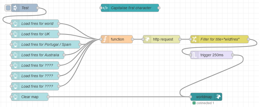
Just created a flow to plot the wild-fires data from NASA (using the EONET category) on the worldmap node. I've placed some buttons on the dashboard to filter the data by regions around the world.

This is what the revised (see Note-A below) Node-RED flow looks like.

[{"id":"8a88f56d6fd5eb7f","type":"tab","label":"Wild Fires","disabled":false,"info":"","env":[]},{"id":"01d9626af51fcc59","type":"ui_button","z":"8a88f56d6fd5eb7f","name":"Load fires for world","group":"d4d2c5a78449ad8a","order":3,"width":2,"height":1,"passthru":true,"label":"World","tooltip":"","color":"","bgcolor":"","className":"","icon":"fa-map","payload":"[-90,90,-180,180]","payloadType":"json","topic":"world","topicType":"str","x":230,"y":200,"wires":[["6862402c5412c3ca"]]},{"id":"6862402c5412c3ca","type":"function","z":"8a88f56d6fd5eb7f","name":"","func":"msg.headers = {\"Accept\":\"text/json\"};\nmsg.url = \"https://eonet.gsfc.nasa.gov/api/v2.1/events\";\nmsg.points = msg.payload;\nreturn msg;","outputs":1,"noerr":0,"initialize":"","finalize":"","libs":[],"x":540,"y":260,"wires":[["3ef74e602820ab02"]]},{"id":"6541e0cae5bdefd0","type":"ui_button","z":"8a88f56d6fd5eb7f","name":"Load fires for UK","group":"d4d2c5a78449ad8a","order":4,"width":2,"height":1,"passthru":true,"label":"UK","tooltip":"","color":"","bgcolor":"","className":"","icon":"fa-map","payload":"[49, 60, -1, 1]","payloadType":"json","topic":"uk","topicType":"str","x":230,"y":240,"wires":[["6862402c5412c3ca"]]},{"id":"64e791c7f3027a6d","type":"ui_button","z":"8a88f56d6fd5eb7f","name":"Load fires for Portugal / Spain","group":"d4d2c5a78449ad8a","order":5,"width":4,"height":1,"passthru":true,"label":"Portugal / Spain","tooltip":"","color":"","bgcolor":"","className":"","icon":"fa-map","payload":"[36, 44, -10, 3]","payloadType":"json","topic":"spain","topicType":"str","x":270,"y":280,"wires":[["6862402c5412c3ca"]]},{"id":"e684d76e8f37a4d9","type":"ui_button","z":"8a88f56d6fd5eb7f","name":"Load fires for Australia","group":"d4d2c5a78449ad8a","order":6,"width":2,"height":1,"passthru":true,"label":"Australia","tooltip":"","color":"","bgcolor":"","className":"","icon":"fa-map","payload":"[-44, -8, 110, 156]","payloadType":"json","topic":"aus","topicType":"str","x":240,"y":320,"wires":[["6862402c5412c3ca"]]},{"id":"fc907e74b1154d6d","type":"ui_button","z":"8a88f56d6fd5eb7f","name":"Load fires for ????","group":"d4d2c5a78449ad8a","order":6,"width":2,"height":1,"passthru":false,"label":"- spare -","tooltip":"","color":"","bgcolor":"","className":"","icon":"fa-map","payload":"","payloadType":"str","topic":"none","topicType":"str","x":230,"y":360,"wires":[["6862402c5412c3ca"]]},{"id":"7f545cfdb4f92794","type":"ui_button","z":"8a88f56d6fd5eb7f","name":"Load fires for ????","group":"d4d2c5a78449ad8a","order":6,"width":2,"height":1,"passthru":false,"label":"- spare -","tooltip":"","color":"","bgcolor":"","className":"","icon":"fa-map","payload":"","payloadType":"str","topic":"none","topicType":"str","x":230,"y":400,"wires":[["6862402c5412c3ca"]]},{"id":"66ca07c8363c197a","type":"ui_button","z":"8a88f56d6fd5eb7f","name":"Load fires for ????","group":"d4d2c5a78449ad8a","order":6,"width":2,"height":1,"passthru":false,"label":"- spare -","tooltip":"","color":"","bgcolor":"","className":"","icon":"fa-map","payload":"","payloadType":"str","topic":"none","topicType":"str","x":230,"y":440,"wires":[["6862402c5412c3ca"]]},{"id":"3ef74e602820ab02","type":"http request","z":"8a88f56d6fd5eb7f","name":"","method":"GET","ret":"obj","paytoqs":"ignore","url":"","tls":"","persist":false,"proxy":"","authType":"","senderr":false,"x":710,"y":260,"wires":[["7df729eab69e1708","9a3cd1a7ab7d6362"]]},{"id":"7df729eab69e1708","type":"change","z":"8a88f56d6fd5eb7f","name":"Filter for title=\"wildfires\"","rules":[{"t":"set","p":"payload","pt":"msg","to":"[$$.payload.events[\t   categories.title = \"Wildfires\" and\t      (geometries[0].coordinates[1] >= $$.points[0] and \t      geometries[0].coordinates[1] <= $$.points[1] and \t      geometries[0].coordinates[0] >= $$.points[2] and \t      geometries[0].coordinates[0] <= $$.points[3])\t].{\t   \"name\": $.id,\t   \"lat\": $.geometries[0].coordinates[1],\t   \"lon\": $.geometries[0].coordinates[0],\t   \"Title\": $.title,\t   \"Date\": $moment($.geometries[0].date).tz(\"Euroupe/london\").format(\"yyyy/MM/DD HH:mm:ss\"),\t   \"icon\": \"fa-fire\"\t    }]","tot":"jsonata"}],"action":"","property":"","from":"","to":"","reg":false,"x":930,"y":260,"wires":[["e681fc3b61902171"]]},{"id":"e681fc3b61902171","type":"trigger","z":"8a88f56d6fd5eb7f","name":"","op1":"{\"command\":{\"clear\":\"unknown\" }}","op2":"","op1type":"json","op2type":"pay","duration":"250","extend":false,"overrideDelay":false,"units":"ms","reset":"","bytopic":"all","topic":"topic","outputs":1,"x":900,"y":320,"wires":[["5bf5b822c3ac1d30"]]},{"id":"93f49530be5de971","type":"ui_button","z":"8a88f56d6fd5eb7f","name":"","group":"d4d2c5a78449ad8a","order":8,"width":2,"height":1,"passthru":false,"label":"Clear map","tooltip":"","color":"","bgcolor":"","className":"","icon":"","payload":"{\"command\":{\"clear\":\"unknown\" }}","payloadType":"json","topic":"","topicType":"str","x":210,"y":480,"wires":[["5bf5b822c3ac1d30"]]},{"id":"5bf5b822c3ac1d30","type":"ui_worldmap","z":"8a88f56d6fd5eb7f","group":"d4d2c5a78449ad8a","order":1,"width":18,"height":14,"name":"","lat":"","lon":"","zoom":"5","layer":"OSMG","cluster":"","maxage":"","usermenu":"show","layers":"show","panit":"true","panlock":"false","zoomlock":"false","hiderightclick":"true","coords":"none","showgrid":"true","allowFileDrop":"false","path":"/worldmap","overlist":"DR,CO,RA,DN,HM","maplist":"OSMG,OSMC,EsriC,EsriS,EsriT,EsriO,EsriDG,NatGeo,UKOS,OpTop","mapname":"","mapurl":"","mapopt":"","mapwms":false,"x":880,"y":480,"wires":[]},{"id":"558f2165096f3674","type":"inject","z":"8a88f56d6fd5eb7f","name":"Test","props":[{"p":"payload"},{"p":"topic","vt":"str"}],"repeat":"","crontab":"","once":false,"onceDelay":0.1,"topic":"","payload":"1","payloadType":"num","x":190,"y":140,"wires":[["01d9626af51fcc59"]]},{"id":"833c8cdd1e496a37","type":"ui_template","z":"8a88f56d6fd5eb7f","group":"d4d2c5a78449ad8a","name":"Capitalise first character","order":2,"width":0,"height":0,"format":"<style>\n    .nr-dashboard-theme .nr-dashboard-button .md-button {\n        text-transform:capitalize;\n    }\n</style>","storeOutMessages":true,"fwdInMessages":true,"resendOnRefresh":true,"templateScope":"local","className":"","x":590,"y":140,"wires":[[]]},{"id":"9a3cd1a7ab7d6362","type":"debug","z":"8a88f56d6fd5eb7f","name":"","active":true,"tosidebar":true,"console":false,"tostatus":false,"complete":"false","statusVal":"","statusType":"auto","x":890,"y":180,"wires":[]},{"id":"7cf0c411adbf93b9","type":"comment","z":"8a88f56d6fd5eb7f","name":"Last modified: 21st May 2022","info":"","x":240,"y":80,"wires":[]},{"id":"d4d2c5a78449ad8a","type":"ui_group","name":"World_map","tab":"47ec854f298fe1a9","order":1,"disp":true,"width":"18","collapse":false,"className":""},{"id":"47ec854f298fe1a9","type":"ui_tab","name":"Wild_fires","icon":"dashboard","order":40,"disabled":false,"hidden":false}]

I've left some -spare- buttons on the dashboard so you can adapt the flow for your specific region.

Note-A: I must give credit to @E1cid for his work creating the Jsonata in the Change node and for his suggestion to set the coordinates for the various regions in the buttons. This simplifies the processing in the Change node and makes the overall flow much simpler and easier to follow.

Note-B: According to the NASA data, there are currently (May, 2022) no wild-fires in Australia.

Note-C: Since taking the screenshots above I've added an 'icon' definition for Worldmap to get this effect.
Screen Shot 05-20-22 at 05.45 AM

Note-D: 21st May 2022 - I've updated the flow to include Title and Date on Worldmap popups, so you can see when the report was posted.
Screen Shot 05-21-22 at 09.28 AM

3 Likes

Thanks very mych @dynamicdave, @jbudd and E1cid, you guys helped a lot.

My flow is complete now and I can now use it in my assigment. My project is simpler than what you are doing here but it will be a great reference for the next assigment. I will post my flow as soon as I get graded.

Thanks once more guys.

1 Like

I've created a tutorial-guide for my IoT students and posted it on "Share Your Projects".
It covers how to plot wildfires using the worldmap node on the Dashboard.

1 Like

This topic was automatically closed 60 days after the last reply. New replies are no longer allowed.