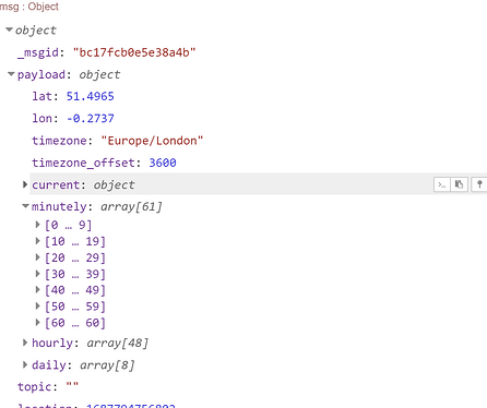
No that's wrong. Their "OneCall" API does allow free access to "current weather, minute forecast for 1 hour, hourly forecast for 48 hours, daily forecast for 8 days"
I have never used the minute by minute forecast so no idea if it matches your experience with DarkSky.
Edit: This flow works for me - but I notice that there is no "Minutely" data.
[{"id":"b5c0d5b07cb01554","type":"function","z":"4f02d48c1fd987a5","name":"Setup","func":"const appid = global.get('openweathermapid'); // Openweathermap OneCall API key\nmsg.location = msg.payload;\nmsg.lat = 21.321775;\nmsg.long = -158.01860\nmsg.url=\"https://api.openweathermap.org/data/2.5/onecall?lat=\" + msg.lat + \"&lon=\" + msg.long + \"&units=metric&appid=\" + appid;\nreturn msg;","outputs":1,"noerr":0,"initialize":"","finalize":"","libs":[],"x":470,"y":300,"wires":[["af36edca67cc19bf"]]},{"id":"af36edca67cc19bf","type":"http request","z":"4f02d48c1fd987a5","name":"Openweathermap","method":"GET","ret":"obj","paytoqs":"ignore","url":"","tls":"","persist":false,"proxy":"","insecureHTTPParser":false,"authType":"","senderr":false,"headers":[],"x":650,"y":300,"wires":[["49ce8f14c2282226"]]},{"id":"49ce8f14c2282226","type":"debug","z":"4f02d48c1fd987a5","name":"debug 389","active":true,"tosidebar":true,"console":false,"tostatus":false,"complete":"false","statusVal":"","statusType":"auto","x":850,"y":300,"wires":[]},{"id":"0b4ea17f33caee20","type":"inject","z":"4f02d48c1fd987a5","name":"","props":[{"p":"payload"},{"p":"topic","vt":"str"}],"repeat":"","crontab":"","once":false,"onceDelay":0.1,"topic":"","payload":"","payloadType":"date","x":320,"y":300,"wires":[["b5c0d5b07cb01554"]]}]
An example of the data returned
{"lat":21.3218,"lon":-158.0186,"timezone":"Pacific/Honolulu","timezone_offset":-36000,"current":{"dt":1687736802,"sunrise":1687708309,"sunset":1687756647,"temp":27.54,"feels_like":28.89,"pressure":1020,"humidity":61,"dew_point":19.35,"uvi":10.73,"clouds":0,"visibility":10000,"wind_speed":9.26,"wind_deg":70,"wind_gust":12.35,"weather":[{"id":500,"main":"Rain","description":"light rain","icon":"10d"}]},"hourly":[{"dt":1687734000,"temp":27.35,"feels_like":28.54,"pressure":1020,"humidity":60,"dew_point":18.9,"uvi":12.35,"clouds":4,"visibility":10000,"wind_speed":10.04,"wind_deg":71,"wind_gust":11.97,"weather":[{"id":800,"main":"Clear","description":"clear sky","icon":"01d"}],"pop":0.18},{"dt":1687737600,"temp":27.54,"feels_like":28.89,"pressure":1020,"humidity":61,"dew_point":19.35,"uvi":10.73,"clouds":0,"visibility":10000,"wind_speed":10.4,"wind_deg":71,"wind_gust":12.64,"weather":[{"id":800,"main":"Clear","description":"clear sky","icon":"01d"}],"pop":0.14},{"dt":1687741200,"temp":27.31,"feels_like":28.48,"pressure":1020,"humidity":60,"dew_point":18.87,"uvi":7.76,"clouds":2,"visibility":10000,"wind_speed":10.27,"wind_deg":73,"wind_gust":12.51,"weather":[{"id":800,"main":"Clear","description":"clear sky","icon":"01d"}],"pop":0},{"dt":1687744800,"temp":26.96,"feels_like":28.17,"pressure":1020,"humidity":62,"dew_point":19.06,"uvi":4.62,"clouds":2,"visibility":10000,"wind_speed":10.05,"wind_deg":70,"wind_gust":12.49,"weather":[{"id":800,"main":"Clear","description":"clear sky","icon":"01d"}],"pop":0},{"dt":1687748400,"temp":26.38,"feels_like":26.38,"pressure":1019,"humidity":64,"dew_point":19.03,"uvi":2.07,"clouds":4,"visibility":10000,"wind_speed":9.68,"wind_deg":67,"wind_gust":12.25,"weather":[{"id":800,"main":"Clear","description":"clear sky","icon":"01d"}],"pop":0},{"dt":1687752000,"temp":25.66,"feels_like":26.03,"pressure":1019,"humidity":67,"dew_point":19.08,"uvi":0.58,"clouds":6,"visibility":10000,"wind_speed":9.2,"wind_deg":66,"wind_gust":11.82,"weather":[{"id":800,"main":"Clear","description":"clear sky","icon":"01d"}],"pop":0},{"dt":1687755600,"temp":24.51,"feels_like":24.92,"pressure":1019,"humidity":73,"dew_point":19.11,"uvi":0,"clouds":8,"visibility":10000,"wind_speed":8.81,"wind_deg":65,"wind_gust":11.61,"weather":[{"id":800,"main":"Clear","description":"clear sky","icon":"01d"}],"pop":0},{"dt":1687759200,"temp":24.4,"feels_like":24.83,"pressure":1020,"humidity":74,"dew_point":19.23,"uvi":0,"clouds":11,"visibility":10000,"wind_speed":8.39,"wind_deg":67,"wind_gust":11.9,"weather":[{"id":801,"main":"Clouds","description":"few clouds","icon":"02n"}],"pop":0},{"dt":1687762800,"temp":24.27,"feels_like":24.74,"pressure":1020,"humidity":76,"dew_point":19.34,"uvi":0,"clouds":25,"visibility":10000,"wind_speed":9.15,"wind_deg":67,"wind_gust":12.23,"weather":[{"id":802,"main":"Clouds","description":"scattered clouds","icon":"03n"}],"pop":0},{"dt":1687766400,"temp":24.14,"feels_like":24.57,"pressure":1020,"humidity":75,"dew_point":19.14,"uvi":0,"clouds":26,"visibility":10000,"wind_speed":9.47,"wind_deg":63,"wind_gust":12.62,"weather":[{"id":802,"main":"Clouds","description":"scattered clouds","icon":"03n"}],"pop":0},{"dt":1687770000,"temp":23.84,"feels_like":24.34,"pressure":1021,"humidity":79,"dew_point":19.47,"uvi":0,"clouds":19,"visibility":10000,"wind_speed":9.35,"wind_deg":64,"wind_gust":12.66,"weather":[{"id":801,"main":"Clouds","description":"few clouds","icon":"02n"}],"pop":0.04},{"dt":1687773600,"temp":23.92,"feels_like":24.4,"pressure":1020,"humidity":78,"dew_point":19.54,"uvi":0,"clouds":21,"visibility":10000,"wind_speed":8.86,"wind_deg":72,"wind_gust":12.32,"weather":[{"id":801,"main":"Clouds","description":"few clouds","icon":"02n"}],"pop":0.11},{"dt":1687777200,"temp":24.03,"feels_like":24.47,"pressure":1020,"humidity":76,"dew_point":19.16,"uvi":0,"clouds":24,"visibility":10000,"wind_speed":8.9,"wind_deg":67,"wind_gust":11.89,"weather":[{"id":801,"main":"Clouds","description":"few clouds","icon":"02n"}],"pop":0.11},{"dt":1687780800,"temp":23.97,"feels_like":24.43,"pressure":1019,"humidity":77,"dew_point":19.26,"uvi":0,"clouds":25,"visibility":10000,"wind_speed":8.66,"wind_deg":67,"wind_gust":11.73,"weather":[{"id":802,"main":"Clouds","description":"scattered clouds","icon":"03n"}],"pop":0.11},{"dt":1687784400,"temp":23.72,"feels_like":24.18,"pressure":1019,"humidity":78,"dew_point":19.36,"uvi":0,"clouds":26,"visibility":10000,"wind_speed":8.52,"wind_deg":63,"wind_gust":11.73,"weather":[{"id":802,"main":"Clouds","description":"scattered clouds","icon":"03n"}],"pop":0.11},{"dt":1687788000,"temp":23.84,"feels_like":24.32,"pressure":1018,"humidity":78,"dew_point":19.43,"uvi":0,"clouds":44,"visibility":10000,"wind_speed":9.37,"wind_deg":65,"wind_gust":12.66,"weather":[{"id":802,"main":"Clouds","description":"scattered clouds","icon":"03n"}],"pop":0.23},{"dt":1687791600,"temp":23.98,"feels_like":24.42,"pressure":1019,"humidity":76,"dew_point":19.23,"uvi":0,"clouds":62,"visibility":10000,"wind_speed":9.36,"wind_deg":74,"wind_gust":12.19,"weather":[{"id":803,"main":"Clouds","description":"broken clouds","icon":"04n"}],"pop":0.35},{"dt":1687795200,"temp":23.95,"feels_like":24.36,"pressure":1019,"humidity":75,"dew_point":18.81,"uvi":0,"clouds":67,"visibility":10000,"wind_speed":8.98,"wind_deg":73,"wind_gust":12.63,"weather":[{"id":803,"main":"Clouds","description":"broken clouds","icon":"04d"}],"pop":0.36},{"dt":1687798800,"temp":24.19,"feels_like":24.6,"pressure":1019,"humidity":74,"dew_point":19.02,"uvi":0.29,"clouds":58,"visibility":10000,"wind_speed":9.1,"wind_deg":71,"wind_gust":12.81,"weather":[{"id":803,"main":"Clouds","description":"broken clouds","icon":"04d"}],"pop":0.4},{"dt":1687802400,"temp":24.81,"feels_like":25.2,"pressure":1020,"humidity":71,"dew_point":18.96,"uvi":1.12,"clouds":51,"visibility":10000,"wind_speed":9.58,"wind_deg":73,"wind_gust":12.65,"weather":[{"id":803,"main":"Clouds","description":"broken clouds","icon":"04d"}],"pop":0.4},{"dt":1687806000,"temp":25.29,"feels_like":25.68,"pressure":1020,"humidity":69,"dew_point":18.95,"uvi":3.92,"clouds":7,"visibility":10000,"wind_speed":10.03,"wind_deg":76,"wind_gust":12.68,"weather":[{"id":800,"main":"Clear","description":"clear sky","icon":"01d"}],"pop":0.18},{"dt":1687809600,"temp":25.82,"feels_like":26.21,"pressure":1020,"humidity":67,"dew_point":18.92,"uvi":6.78,"clouds":9,"visibility":10000,"wind_speed":10.01,"wind_deg":76,"wind_gust":12.31,"weather":[{"id":800,"main":"Clear","description":"clear sky","icon":"01d"}],"pop":0.23},{"dt":1687813200,"temp":26.25,"feels_like":26.25,"pressure":1020,"humidity":65,"dew_point":18.76,"uvi":9.48,"clouds":8,"visibility":10000,"wind_speed":9.71,"wind_deg":77,"wind_gust":11.92,"weather":[{"id":800,"main":"Clear","description":"clear sky","icon":"01d"}],"pop":0.24},{"dt":1687816800,"temp":26.43,"feels_like":26.43,"pressure":1019,"humidity":63,"dew_point":18.46,"uvi":11.46,"clouds":7,"visibility":10000,"wind_speed":10.15,"wind_deg":77,"wind_gust":11.8,"weather":[{"id":800,"main":"Clear","description":"clear sky","icon":"01d"}],"pop":0.22},{"dt":1687820400,"temp":26.53,"feels_like":26.53,"pressure":1019,"humidity":64,"dew_point":18.8,"uvi":11.58,"clouds":5,"visibility":10000,"wind_speed":10.36,"wind_deg":76,"wind_gust":12.04,"weather":[{"id":800,"main":"Clear","description":"clear sky","icon":"01d"}],"pop":0.22},{"dt":1687824000,"temp":26.45,"feels_like":26.45,"pressure":1019,"humidity":65,"dew_point":19.12,"uvi":10.07,"clouds":5,"visibility":10000,"wind_speed":10.6,"wind_deg":74,"wind_gust":11.88,"weather":[{"id":800,"main":"Clear","description":"clear sky","icon":"01d"}],"pop":0.18},{"dt":1687827600,"temp":26.29,"feels_like":26.29,"pressure":1018,"humidity":66,"dew_point":19.13,"uvi":7.51,"clouds":0,"visibility":10000,"wind_speed":10.6,"wind_deg":73,"wind_gust":11.42,"weather":[{"id":800,"main":"Clear","description":"clear sky","icon":"01d"}],"pop":0},{"dt":1687831200,"temp":26.03,"feels_like":26.03,"pressure":1018,"humidity":66,"dew_point":18.83,"uvi":4.48,"clouds":0,"visibility":10000,"wind_speed":10.08,"wind_deg":74,"wind_gust":11.22,"weather":[{"id":800,"main":"Clear","description":"clear sky","icon":"01d"}],"pop":0},{"dt":1687834800,"temp":25.69,"feels_like":26.12,"pressure":1018,"humidity":69,"dew_point":19.14,"uvi":2.01,"clouds":0,"visibility":10000,"wind_speed":9.7,"wind_deg":73,"wind_gust":11.68,"weather":[{"id":800,"main":"Clear","description":"clear sky","icon":"01d"}],"pop":0},{"dt":1687838400,"temp":25.12,"feels_like":25.57,"pressure":1018,"humidity":72,"dew_point":19.28,"uvi":0.57,"clouds":1,"visibility":10000,"wind_speed":9.43,"wind_deg":72,"wind_gust":11.59,"weather":[{"id":800,"main":"Clear","description":"clear sky","icon":"01d"}],"pop":0},{"dt":1687842000,"temp":24.66,"feels_like":25.14,"pressure":1019,"humidity":75,"dew_point":19.52,"uvi":0,"clouds":3,"visibility":10000,"wind_speed":8.77,"wind_deg":71,"wind_gust":11.49,"weather":[{"id":800,"main":"Clear","description":"clear sky","icon":"01d"}],"pop":0},{"dt":1687845600,"temp":24.41,"feels_like":24.89,"pressure":1019,"humidity":76,"dew_point":19.57,"uvi":0,"clouds":5,"visibility":10000,"wind_speed":8.12,"wind_deg":69,"wind_gust":10.96,"weather":[{"id":800,"main":"Clear","description":"clear sky","icon":"01n"}],"pop":0},{"dt":1687849200,"temp":24.31,"feels_like":24.75,"pressure":1020,"humidity":75,"dew_point":19.17,"uvi":0,"clouds":11,"visibility":10000,"wind_speed":8.07,"wind_deg":69,"wind_gust":10.86,"weather":[{"id":801,"main":"Clouds","description":"few clouds","icon":"02n"}],"pop":0.17},{"dt":1687852800,"temp":24.19,"feels_like":24.62,"pressure":1020,"humidity":75,"dew_point":19.31,"uvi":0,"clouds":8,"visibility":10000,"wind_speed":8.24,"wind_deg":69,"wind_gust":11.08,"weather":[{"id":800,"main":"Clear","description":"clear sky","icon":"01n"}],"pop":0.12},{"dt":1687856400,"temp":24.11,"feels_like":24.51,"pressure":1020,"humidity":74,"dew_point":18.87,"uvi":0,"clouds":8,"visibility":10000,"wind_speed":8.69,"wind_deg":69,"wind_gust":11.16,"weather":[{"id":800,"main":"Clear","description":"clear sky","icon":"01n"}],"pop":0.09},{"dt":1687860000,"temp":23.94,"feels_like":24.3,"pressure":1020,"humidity":73,"dew_point":18.51,"uvi":0,"clouds":6,"visibility":10000,"wind_speed":8.54,"wind_deg":67,"wind_gust":11.34,"weather":[{"id":800,"main":"Clear","description":"clear sky","icon":"01n"}],"pop":0.06},{"dt":1687863600,"temp":23.75,"feels_like":24.22,"pressure":1019,"humidity":78,"dew_point":19.3,"uvi":0,"clouds":5,"visibility":10000,"wind_speed":8.2,"wind_deg":68,"wind_gust":11.62,"weather":[{"id":800,"main":"Clear","description":"clear sky","icon":"01n"}],"pop":0.06},{"dt":1687867200,"temp":23.9,"feels_like":24.36,"pressure":1018,"humidity":77,"dew_point":19.36,"uvi":0,"clouds":9,"visibility":10000,"wind_speed":9,"wind_deg":69,"wind_gust":11.93,"weather":[{"id":800,"main":"Clear","description":"clear sky","icon":"01n"}],"pop":0.06},{"dt":1687870800,"temp":23.79,"feels_like":24.21,"pressure":1018,"humidity":76,"dew_point":19.03,"uvi":0,"clouds":32,"visibility":10000,"wind_speed":9.59,"wind_deg":71,"wind_gust":12.14,"weather":[{"id":802,"main":"Clouds","description":"scattered clouds","icon":"03n"}],"pop":0.06},{"dt":1687874400,"temp":23.7,"feels_like":24.06,"pressure":1017,"humidity":74,"dew_point":18.41,"uvi":0,"clouds":21,"visibility":10000,"wind_speed":9.3,"wind_deg":71,"wind_gust":11.64,"weather":[{"id":801,"main":"Clouds","description":"few clouds","icon":"02n"}],"pop":0.01},{"dt":1687878000,"temp":23.62,"feels_like":23.94,"pressure":1018,"humidity":73,"dew_point":18.1,"uvi":0,"clouds":15,"visibility":10000,"wind_speed":8.9,"wind_deg":73,"wind_gust":11.22,"weather":[{"id":801,"main":"Clouds","description":"few clouds","icon":"02n"}],"pop":0.02},{"dt":1687881600,"temp":23.71,"feels_like":23.91,"pressure":1018,"humidity":68,"dew_point":17.21,"uvi":0,"clouds":14,"visibility":10000,"wind_speed":8.33,"wind_deg":72,"wind_gust":10.85,"weather":[{"id":801,"main":"Clouds","description":"few clouds","icon":"02d"}],"pop":0.05},{"dt":1687885200,"temp":24.27,"feels_like":24.5,"pressure":1019,"humidity":67,"dew_point":17.49,"uvi":0.46,"clouds":13,"visibility":10000,"wind_speed":7.58,"wind_deg":72,"wind_gust":10.29,"weather":[{"id":801,"main":"Clouds","description":"few clouds","icon":"02d"}],"pop":0.02},{"dt":1687888800,"temp":24.8,"feels_like":25.16,"pressure":1019,"humidity":70,"dew_point":18.51,"uvi":1.74,"clouds":12,"visibility":10000,"wind_speed":8.55,"wind_deg":77,"wind_gust":10.37,"weather":[{"id":801,"main":"Clouds","description":"few clouds","icon":"02d"}],"pop":0.02},{"dt":1687892400,"temp":25.23,"feels_like":25.66,"pressure":1019,"humidity":71,"dew_point":19.17,"uvi":3.23,"clouds":11,"visibility":10000,"wind_speed":9.03,"wind_deg":75,"wind_gust":10.4,"weather":[{"id":801,"main":"Clouds","description":"few clouds","icon":"02d"}],"pop":0.04},{"dt":1687896000,"temp":25.58,"feels_like":26.02,"pressure":1019,"humidity":70,"dew_point":19.28,"uvi":5.61,"clouds":13,"visibility":10000,"wind_speed":9.46,"wind_deg":73,"wind_gust":10.5,"weather":[{"id":801,"main":"Clouds","description":"few clouds","icon":"02d"}],"pop":0.04},{"dt":1687899600,"temp":25.95,"feels_like":25.95,"pressure":1019,"humidity":68,"dew_point":19.18,"uvi":7.83,"clouds":17,"visibility":10000,"wind_speed":9.52,"wind_deg":73,"wind_gust":10.12,"weather":[{"id":801,"main":"Clouds","description":"few clouds","icon":"02d"}],"pop":0},{"dt":1687903200,"temp":26.19,"feels_like":26.19,"pressure":1018,"humidity":65,"dew_point":18.78,"uvi":11.87,"clouds":15,"visibility":10000,"wind_speed":9.28,"wind_deg":72,"wind_gust":9.85,"weather":[{"id":801,"main":"Clouds","description":"few clouds","icon":"02d"}],"pop":0}],"daily":[{"dt":1687730400,"sunrise":1687708309,"sunset":1687756647,"moonrise":1687731360,"moonset":1687687680,"moon_phase":0.25,"temp":{"day":26.84,"min":23.45,"max":27.54,"night":23.84,"eve":25.66,"morn":23.45},"feels_like":{"day":28.02,"night":24.34,"eve":26.03,"morn":23.68},"pressure":1020,"humidity":62,"dew_point":18.95,"wind_speed":10.56,"wind_deg":71,"wind_gust":13.62,"weather":[{"id":800,"main":"Clear","description":"clear sky","icon":"01d"}],"clouds":8,"pop":0.19,"uvi":12.35},{"dt":1687816800,"sunrise":1687794725,"sunset":1687843056,"moonrise":1687820820,"moonset":1687775940,"moon_phase":0.27,"temp":{"day":26.43,"min":23.72,"max":26.53,"night":24.11,"eve":25.12,"morn":23.95},"feels_like":{"day":26.43,"night":24.51,"eve":25.57,"morn":24.36},"pressure":1019,"humidity":63,"dew_point":18.46,"wind_speed":10.6,"wind_deg":74,"wind_gust":12.81,"weather":[{"id":800,"main":"Clear","description":"clear sky","icon":"01d"}],"clouds":7,"pop":0.4,"uvi":11.58},{"dt":1687903200,"sunrise":1687881141,"sunset":1687929463,"moonrise":1687910280,"moonset":1687864260,"moon_phase":0.3,"temp":{"day":26.19,"min":23.62,"max":26.65,"night":24.01,"eve":25.27,"morn":23.71},"feels_like":{"day":26.19,"night":24.32,"eve":25.58,"morn":23.91},"pressure":1018,"humidity":65,"dew_point":18.78,"wind_speed":9.59,"wind_deg":71,"wind_gust":12.14,"weather":[{"id":801,"main":"Clouds","description":"few clouds","icon":"02d"}],"clouds":15,"pop":0.06,"uvi":11.99},{"dt":1687989600,"sunrise":1687967557,"sunset":1688015870,"moonrise":1687999980,"moonset":1687952700,"moon_phase":0.33,"temp":{"day":26.31,"min":23.61,"max":27.02,"night":24.29,"eve":26.3,"morn":23.94},"feels_like":{"day":26.31,"night":24.76,"eve":26.3,"morn":24.37},"pressure":1018,"humidity":67,"dew_point":19.34,"wind_speed":8.73,"wind_deg":74,"wind_gust":11.53,"weather":[{"id":500,"main":"Rain","description":"light rain","icon":"10d"}],"clouds":14,"pop":0.22,"rain":0.14,"uvi":11.89},{"dt":1688076000,"sunrise":1688053975,"sunset":1688102275,"moonrise":1688089980,"moonset":1688041320,"moon_phase":0.37,"temp":{"day":26.83,"min":23.97,"max":27.4,"night":24.52,"eve":26.54,"morn":23.98},"feels_like":{"day":28,"night":25.01,"eve":26.54,"morn":24.42},"pressure":1018,"humidity":62,"dew_point":18.53,"wind_speed":7.81,"wind_deg":78,"wind_gust":9.66,"weather":[{"id":800,"main":"Clear","description":"clear sky","icon":"01d"}],"clouds":3,"pop":0.21,"uvi":12.34},{"dt":1688162400,"sunrise":1688140392,"sunset":1688188680,"moonrise":1688180160,"moonset":1688130360,"moon_phase":0.4,"temp":{"day":27.09,"min":24.1,"max":27.37,"night":24.44,"eve":26.68,"morn":24.34},"feels_like":{"day":28.35,"night":24.9,"eve":27.87,"morn":24.74},"pressure":1019,"humidity":62,"dew_point":18.67,"wind_speed":8.08,"wind_deg":74,"wind_gust":8.76,"weather":[{"id":800,"main":"Clear","description":"clear sky","icon":"01d"}],"clouds":3,"pop":0.2,"uvi":13},{"dt":1688248800,"sunrise":1688226811,"sunset":1688275083,"moonrise":1688270580,"moonset":1688219820,"moon_phase":0.44,"temp":{"day":26.68,"min":23.91,"max":27.34,"night":24.61,"eve":26.59,"morn":23.91},"feels_like":{"day":27.94,"night":25.08,"eve":26.59,"morn":24.34},"pressure":1019,"humidity":64,"dew_point":18.89,"wind_speed":6.32,"wind_deg":89,"wind_gust":7.07,"weather":[{"id":500,"main":"Rain","description":"light rain","icon":"10d"}],"clouds":23,"pop":0.24,"rain":0.29,"uvi":13},{"dt":1688335200,"sunrise":1688313230,"sunset":1688361486,"moonrise":1688360940,"moonset":1688309760,"moon_phase":0.48,"temp":{"day":26.54,"min":24,"max":27.35,"night":24.36,"eve":26.7,"morn":24},"feels_like":{"day":26.54,"night":24.81,"eve":27.96,"morn":24.34},"pressure":1019,"humidity":67,"dew_point":19.41,"wind_speed":7.82,"wind_deg":81,"wind_gust":8.9,"weather":[{"id":500,"main":"Rain","description":"light rain","icon":"10d"}],"clouds":6,"pop":0.32,"rain":0.11,"uvi":13}],"alerts":[{"sender_name":"NWS Honolulu (Hawaii)","event":"High Surf Advisory","start":1687698180,"end":1687795200,"description":"...HIGH SURF ADVISORY FOR SOUTH FACING SHORES OF ALL ISLANDS...\n.A long-period south-southeast swell (170 degrees) will peak\ntoday, then briefly diminish. A second pulse arriving Monday\ncould keep surf elevated through early next week.\n...HIGH SURF ADVISORY REMAINS IN EFFECT UNTIL 6 AM HST MONDAY...\n* WHAT...Surf 8 to 12 feet.\n* WHERE...South facing shores of all islands.\n* WHEN...Until 6 AM HST Monday.\n* IMPACTS...Moderate. Strong breaking waves and strong currents\nwill make swimming dangerous.","tags":["Marine event"]}]}
Absolutely! I'm pretty well used to the detailed documentation for APIs not giving me any idea how to use them but the Met office really shines here.
I have managed to retrieve forecast data from the Met Office but I failed with the weather maps.
There is a discussion about the Met Office API at https://discourse.nodered.org/t/http-get-format-for-uk-met-office-api/79255/3
It's hard to know how often the providers update their models or where they get their data from.
You can get what is pretty much guaranteed current info from airport METAR APIs but while they give figures for wind, precipitation info is only a (standardised) text description.
![]()


